
RTK Base Station Accurate Positioning for Modern Land Surveying
What is an RTK Base Station?
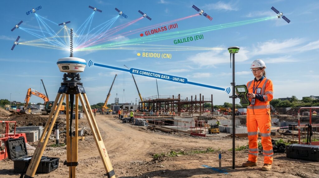
An RTK Base Station is a fixed GNSS receiver that sends correction data to one or more RTK Rover receivers. These corrections improve the accuracy of satellite positioning and allow surveyors to achieve centimeter-level results in real time.
The base station is installed on a point with known coordinates or on a temporary control point. While it continuously receives signals from GNSS satellites, it calculates positioning errors and broadcasts correction data to the rover. The rover applies these corrections instantly, making field measurements much more accurate than standard GPS positioning.
RTK Base Stations are widely used in land surveying, construction, road projects, mapping, mining, agriculture, and engineering surveys where high positional accuracy is required.
How Does an RTK Base Station Work?
An RTK Base Station remains fixed during the survey. It receives satellite signals from multiple GNSS constellations such as GPS, GLONASS, Galileo, and BeiDou. Since the base station knows its exact location, it can determine the difference between its true position and the satellite-calculated position.
This difference is converted into correction data and transmitted to the RTK Rover through a UHF radio, mobile internet, or an NTRIP network. The rover applies these corrections in real time, allowing surveyors to collect highly accurate coordinates while moving around the project site.
Why is an RTK Base Station Important?
Modern engineering projects require precise positioning. Even small errors can affect construction quality, mapping accuracy, and project costs. An RTK Base Station helps reduce these errors by providing real-time corrections, allowing surveyors to work faster and with greater confidence.
It also eliminates the need for repeated measurements in many situations, improving field productivity and reducing the overall survey time.
Common Applications
RTK Base Stations are used for topographic surveys, construction layout, road alignment, control surveys, boundary surveys, utility mapping, mining operations, machine control, precision agriculture, drone mapping, and GIS data collection. They are also widely used to establish accurate survey control for large engineering projects.
Key Features
Real-time centimeter-level positioning
Supports GPS, GLONASS, Galileo, and BeiDou satellites
Provides correction data to one or multiple RTK Rovers
Works through UHF radio, GSM, 4G, or NTRIP networks
Suitable for long-duration survey projects
High reliability in professional engineering applications
Components of an RTK Base Station
Components of an RTK Base Station
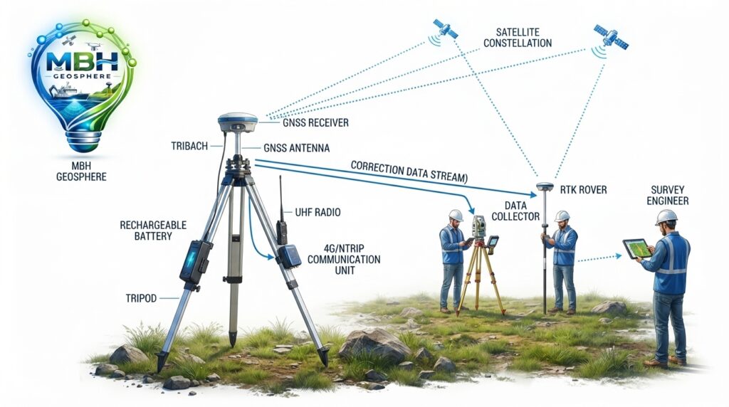
An RTK Base Station is made up of several important components that work together to provide accurate positioning corrections. Each part plays a different role in ensuring reliable survey results.
GNSS Receiver
The GNSS receiver is the main unit of the base station. It receives signals from GPS, GLONASS, Galileo, and BeiDou satellites and calculates accurate position data. Modern receivers can track multiple satellite constellations at the same time, improving accuracy and reliability.
GNSS Antenna
The GNSS antenna receives satellite signals and passes them to the receiver. Survey-grade antennas are designed to reduce signal interference and multipath errors, allowing the base station to produce more accurate correction data.
Survey Tripod
The tripod provides a stable platform for the base station. It should be placed on firm ground and carefully leveled to keep the antenna in a fixed position throughout the survey.
Tribrach
A tribrach connects the GNSS antenna or receiver to the tripod. It allows precise centering over a survey control point and makes it easier to level the equipment accurately.
Communication System
The base station sends correction data to the RTK Rover through different communication methods. Common options include UHF radio, 4G mobile internet, Wi-Fi, and NTRIP networks. The best method depends on the project location and communication range.
Battery and Power Supply
Most RTK Base Stations operate using rechargeable batteries. For long survey projects, external batteries or solar power systems can be used to keep the equipment running for extended periods.
How to Set Up an RTK Base Station
Choose a location with a clear view of the sky and place the tripod on stable ground. Position the tripod directly over the survey control point and level it carefully. Install the tribrach, attach the GNSS antenna and receiver, and measure the antenna height accurately.
Switch on the receiver and configure the survey settings. Select the required coordinate system and communication method. Once the receiver has established a stable satellite solution, start transmitting correction data to the RTK Rover. Before beginning the survey, confirm that the rover has received the correction signal and is showing an RTK Fixed solution.
Communication Methods
RTK Base Stations can transmit correction data using several methods. UHF radio is commonly used on construction sites where mobile network coverage is limited. NTRIP is widely used when internet access is available because it provides correction data over mobile networks. Some survey systems also support Wi-Fi or Bluetooth for short-range communication.
Best Practices
Always install the base station in an open area away from tall buildings, trees, and power lines. Check the battery level before starting work and confirm that all cables and connections are secure. Record the antenna height carefully because incorrect measurements can affect the final survey accuracy. Monitor satellite status during the survey to ensure a stable RTK Fixed solution.

Advantages of an RTK Base Station
An RTK Base Station provides very high positioning accuracy, making it one of the most reliable tools for professional land surveying. With real-time correction data, surveyors can measure points with centimeter-level accuracy without waiting for post-processing.
It also increases productivity because measurements can be collected quickly while maintaining consistent accuracy across the entire project. This saves time, reduces fieldwork, and improves the quality of survey results.
Another advantage is that one RTK Base Station can provide correction data to multiple RTK Rovers at the same time. This allows several survey teams to work together on large projects, improving efficiency and reducing project duration.
RTK Base Stations support different communication methods such as UHF radio, 4G internet, and NTRIP, making them suitable for a wide range of survey environments.
Limitations of an RTK Base Station
Although RTK Base Stations are highly accurate, they also have some limitations. A clear view of the sky is important for receiving strong satellite signals. Tall buildings, dense trees, mountains, and other obstacles can reduce signal quality and affect positioning accuracy.
Communication between the base station and the rover must remain stable throughout the survey. Weak radio signals or poor mobile network coverage can interrupt correction data and cause the rover to lose its RTK Fixed solution.
The operating range of a local RTK Base Station is also limited. As the distance between the base station and the rover increases, positioning accuracy may decrease. For large projects, surveyors often use CORS or NTRIP networks instead of a single local base station.
Industries That Use RTK Base Stations
RTK Base Stations are widely used across many industries where accurate positioning is essential.
Construction companies use RTK systems for site layout, foundation setting out, and infrastructure development.
Land surveyors use RTK Base Stations for boundary surveys, topographic mapping, and control surveys.
Road and railway engineers rely on RTK technology for alignment surveys and construction monitoring.
Mining companies use RTK positioning for stockpile measurements, machine guidance, and mine planning.
Agricultural professionals use RTK systems for precision farming, field mapping, and automated machinery.
Utility companies use RTK equipment to map underground services, power lines, pipelines, and communication networks.
Drone operators use RTK Base Stations to improve the accuracy of aerial mapping and photogrammetry projects.
Choosing the Right RTK Base Station
When selecting an RTK Base Station, surveyors should consider satellite tracking capability, communication options, battery life, environmental protection, operating range, and compatibility with survey software.
A receiver that supports GPS, GLONASS, Galileo, and BeiDou provides better satellite coverage and more reliable positioning. Long battery life and a rugged weather-resistant design are also important for field operations.
Frequently Asked Questions
What is an RTK Base Station?
An RTK Base Station is a fixed GNSS receiver that provides real-time correction data to RTK Rover receivers. These corrections improve positioning accuracy from a few meters to centimeter-level accuracy.
What is the Difference Between an RTK Base Station and an RTK Rover?
An RTK Base Station stays at a fixed location and calculates correction data using satellite signals. An RTK Rover is the mobile receiver carried by the surveyor. The rover receives correction data from the base station and uses it to determine highly accurate positions in real time.
How Accurate is an RTK Base Station?
An RTK Base Station can provide horizontal accuracy of approximately 1 to 2 centimeters and vertical accuracy of around 2 to 3 centimeters when operating under good satellite visibility and stable communication conditions.
What Communication Methods Can an RTK Base Station Use?
An RTK Base Station can transmit correction data through UHF radio, GSM, 4G or 5G mobile networks, Wi-Fi, and NTRIP services. The best communication method depends on the project location and available network coverage.
How Far Can an RTK Base Station Transmit Corrections?
The communication range depends on the equipment and transmission method. UHF radio commonly provides several kilometers of coverage in open areas, while NTRIP can deliver correction data over much greater distances through the internet.
Can One RTK Base Station Support Multiple Rovers?
Yes. A single RTK Base Station can send correction data to multiple RTK Rover receivers at the same time, allowing several survey teams to work efficiently on the same project.
What Projects Use RTK Base Stations?
RTK Base Stations are used for topographic surveys, boundary surveys, construction layout, road and railway projects, mining surveys, utility mapping, precision agriculture, GIS data collection, and drone mapping.
Maintenance
Regular maintenance helps keep an RTK Base Station accurate and reliable. Clean the GNSS antenna and receiver after fieldwork to remove dust, mud, and moisture. Check the tripod, tribrach, batteries, cables, and connectors before every survey. Update the receiver firmware when new versions are available and store the equipment in a dry protective case when not in use. Routine calibration and inspection help maintain long-term accuracy.
Safety
Always install the RTK Base Station on stable ground away from moving vehicles and construction machinery. Choose an open location with a clear view of the sky and avoid placing the antenna near tall buildings, trees, or overhead power lines. Secure the tripod properly to prevent movement caused by wind or accidental contact. During thunderstorms or severe weather, stop surveying immediately and move the equipment to a safe location.