
Side Scan Sonar (SSS)
See What Lies on the Seabed
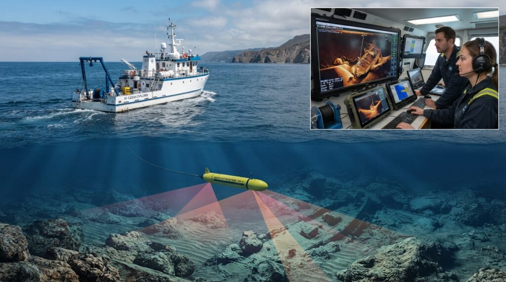
Before building a port, laying an underwater pipeline, installing a submarine cable, or starting a dredging project, engineers need to know what is on the seabed.
A Side Scan Sonar (SSS) helps answer this question.
It is a survey system that creates detailed images of the seabed using sound waves. Instead of measuring water depth, it shows the shape, texture, and objects lying on the bottom of the sea, river, or lake.
Side Scan Sonar can detect rocks, pipelines, shipwrecks, cables, anchors, debris, and many other underwater objects that cannot be seen from the surface.
Today, it is one of the most widely used tools in hydrographic and geophysical surveys because it helps engineers understand the seabed before construction begins.
What is Side Scan Sonar?
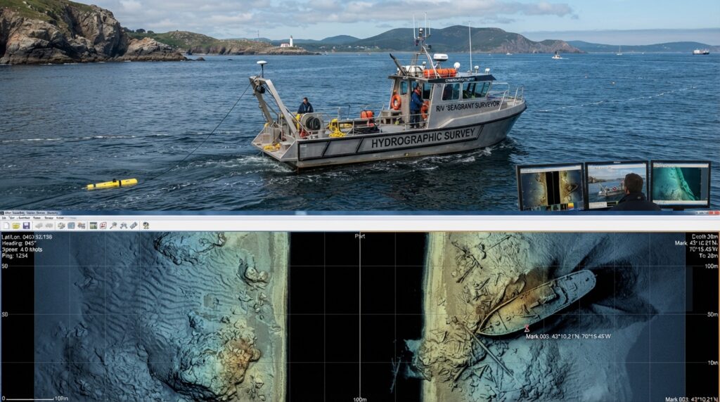
A Side Scan Sonar is an underwater acoustic imaging system.
It sends sound waves to both sides of the survey vessel and records the returning echoes. The echoes are processed into detailed images of the seabed.
This allows surveyors to detect underwater objects that cannot be seen from the surface.
Why is Side Scan Sonar Important?
A Side Scan Sonar is an underwater imaging system that uses sound waves to create clear pictures of the seabed.
The system sends acoustic signals to both sides of the survey vessel. When these sound waves hit the seabed or an underwater object, they bounce back to the sonar.
The returned signals are processed by a computer to create high-resolution images that help surveyors identify natural features and man-made objects.
Unlike a Single Beam Echo Sounder or Multibeam Echo Sounder, Side Scan Sonar is mainly used for seabed imaging, not for measuring water depth.
Why is Side Scan Sonar Important?
Many marine construction projects begin with a seabed survey.
If engineers do not know what is lying on the seabed, they may face unexpected problems during construction.
Side Scan Sonar helps survey teams:
Locate underwater pipelines
Find submarine cables
Detect shipwrecks
Identify rocks and boulders
Locate debris and lost objects
- Inspect dredging areas
- Plan offshore construction safely
By providing clear seabed images, it helps reduce risks, save time, and improve project planning.
Where is Side Scan Sonar Used?
Side Scan Sonar is used in many marine industries, including:
Hydrographic Surveys
Geophysical Surveys
Offshore Oil & Gas Projects
Dredging Operations
Port Development
Harbor Surveys
Pipeline Route Surveys
Submarine Cable Surveys
Search and Recovery Operations
Environmental Monitoring
Marine Archaeology
Offshore Wind Farm Projects
Quick Facts
| Feature | Details |
|---|---|
| Full Name | Side Scan Sonar |
| Short Name | SSS |
| Technology | Acoustic Imaging |
| Main Purpose | Create images of the seabed |
| Platform | Survey Vessel or USV |
| Output | High-resolution seabed images |
| Common Users | Hydrographic and Geophysical Survey Teams |
Did You Know?
A Side Scan Sonar can scan both sides of a survey vessel at the same time, allowing large areas of the seabed to be surveyed much faster than visual inspections by divers.
How Does Side Scan Sonar Work?
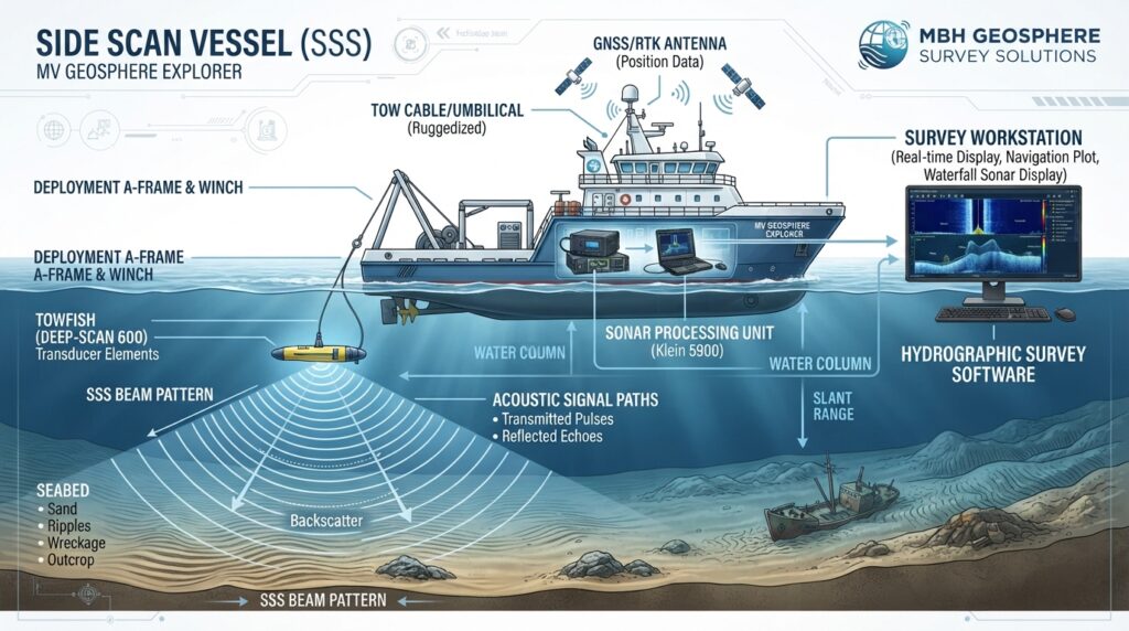
A Side Scan Sonar uses sound waves to create detailed images of the seabed. The system sends sound pulses to both sides of the survey vessel. When these sound waves hit the seabed or an underwater object, they bounce back to the sonar.
The returning echoes are processed by the survey computer and converted into high-quality seabed images. These images help surveyors identify underwater objects and understand the condition of the seabed.
The survey vessel follows planned survey lines to ensure complete coverage of the survey area.
Step-by-Step Working Process
Step 1 – Survey Planning
Before the survey begins, engineers plan the survey area and create survey lines using hydrographic survey software.
Step 2 – Equipment Setup
The Side Scan Sonar system is installed on a survey vessel or an Uncrewed Surface Vessel (USV). The GNSS receiver is connected to provide accurate positioning.
Step 3 – Deploy the Towfish
The Side Scan Sonar towfish is lowered into the water and towed behind the vessel at a safe distance.
Keeping the towfish behind the vessel helps reduce noise and produces clearer seabed images.
Step 4 – Sonar Scanning
The towfish continuously sends sound waves to both the left and right sides of the seabed.
When the sound waves hit rocks, pipelines, cables, or other objects, they reflect back to the sonar sensor.
Step 5 – Data Collection
The survey computer records both the sonar images and the vessel’s position.
This allows every detected object to be displayed at its correct location.
Step 6 – Data Processing
After the survey is complete, the collected data is processed using hydrographic software.
The final images help engineers identify underwater features and prepare survey reports.
Main Components of a Side Scan Sonar System
A complete Side Scan Sonar system includes several important components.
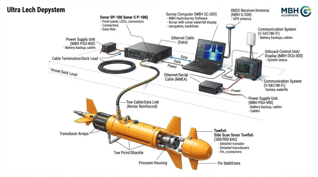
Side Scan Sonar Towfish
The towfish is the main sensor of the system. It sends and receives acoustic signals while being towed behind the survey vessel.
Tow Cable
The tow cable connects the towfish to the survey vessel. It supplies power and transfers sonar data to the onboard computer.
Sonar Processor
The sonar processor converts the received acoustic signals into detailed seabed images.
GNSS Receiver
The GNSS receiver records the exact position of the survey vessel so every sonar image is correctly located on the survey map.
Survey Computer
The survey computer displays the sonar images in real time and stores the collected data.
Survey Software
Specialized hydrographic software is used to view, process, edit, and export the survey results.
Power Supply
The power supply provides stable electrical power to the entire Side Scan Sonar system.
Types of Side Scan Sonar
Different survey projects require different types of Side Scan Sonar systems.
Towfish Side Scan Sonar
The most common type.
The sonar is towed behind the survey vessel and provides excellent image quality.
Best for:
- Hydrographic Surveys
- Geophysical Surveys
- Offshore Projects
Hull-Mounted Side Scan Sonar
The sonar is permanently installed under the survey vessel.
Best for:
- Long-term survey vessels
- Port surveys
- Harbor monitoring
USV Mounted Side Scan Sonar
The sonar is installed on an Uncrewed Surface Vessel (USV).
Best for:
- Shallow water surveys
- Dangerous areas
- Autonomous surveys
ROV Mounted Side Scan Sonar
The sonar is mounted on a Remotely Operated Vehicle (ROV).
Best for:
- Underwater inspections
- Bridge inspections
- Offshore structures
- Deep-water surveys
Typical Technical Specifications
| Feature | Typical Value |
|---|---|
| Technology | Acoustic Sonar |
| Operating Frequency | 100–900 kHz (Model Dependent) |
| Maximum Range | Up to 500 m per side |
| Survey Speed | 3–6 Knots |
| Platform | Survey Vessel / USV / ROV |
| Positioning | GNSS / RTK |
| Output | High-Resolution Seabed Images |
| Data Format | Sonar Mosaic & Image Files |
Survey Workflow
A typical Side Scan Sonar survey follows these steps:
- Survey Planning
- Equipment Installation
- GNSS Configuration
- Towfish Deployment
- Sonar Data Collection
- Quality Check
- Data Processing
- Image Interpretation
- Final Survey Report
Best Survey Practices
To achieve high-quality results:
- Plan survey lines before starting.
- Maintain a steady vessel speed.
- Keep the towfish at the correct height above the seabed.
- Check GNSS positioning throughout the survey.
- Avoid sudden turns during data collection.
- Review sonar images regularly for quality.
- Process the data carefully before creating the final report.
Applications of Side Scan Sonar
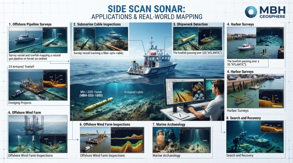
A Side Scan Sonar is used in many types of marine surveys because it provides clear images of the seabed. It helps surveyors find underwater objects and understand seabed conditions before construction or inspection work begins.
Below are some of the most common applications.
Hydrographic Surveys
Side Scan Sonar is widely used in hydrographic surveys to create detailed images of the seabed. It helps surveyors identify rocks, debris, and other objects that may affect navigation or construction.
Geophysical Surveys
In geophysical surveys, Side Scan Sonar is used together with other equipment such as a Magnetometer and Sub Bottom Profiler. This combination provides a better understanding of both the seabed surface and what lies beneath it.
Pipeline Route Surveys
Before installing an offshore pipeline, engineers need to check if the route is clear.
Side Scan Sonar helps locate existing pipelines, rocks, debris, and other obstacles that could affect installation.
Submarine Cable Surveys
Power and communication cables are installed on the seabed.
Side Scan Sonar is used to inspect cable routes and locate existing cables before new ones are installed.
Dredging Projects
Before and after dredging, survey teams use Side Scan Sonar to inspect the seabed.
It helps identify remaining debris, large rocks, or other objects that may need to be removed.
Port and Harbor Surveys
Ports and harbors require regular inspections to keep navigation channels safe.
Side Scan Sonar helps detect sunken objects, damaged structures, and seabed changes.
Shipwreck Detection
One of the most common uses of Side Scan Sonar is finding shipwrecks.
Its high-quality seabed images make it easier to locate wrecks, even in deep water.
Search and Recovery Operations
When an object is lost underwater, Side Scan Sonar can quickly scan large areas and help locate:
- Sunken boats
- Anchors
- Vehicles
- Aircraft wreckage
- Lost equipment
Marine Archaeology
Marine archaeologists use Side Scan Sonar to locate historical shipwrecks and underwater ruins without disturbing the seabed.
Advantages of Side Scan Sonar
Side Scan Sonar offers many benefits for marine survey projects.
- Produces detailed seabed images
- Covers large survey areas quickly
- Detects underwater objects with high accuracy
- Works in shallow and deep water
- Improves survey planning
- Reduces inspection time
- Supports safer marine construction
- Easy to combine with GNSS and other survey systems
Limitations of Side Scan Sonar
Although Side Scan Sonar is a powerful survey tool, it also has some limitations.
- It does not measure water depth directly.
- Soft mud can reduce image clarity.
- Rough sea conditions may affect image quality.
- Proper towfish height is important for good results.
- Image interpretation requires trained surveyors.
Popular Side Scan Sonar Models
Some well-known models include:
- EdgeTech 4200 Series
- EdgeTech 4125 Series
- Klein 3900 Series
- Klein 4900 Series
- Marine Sonic ARC Explorer
- DeepVision DE3468
- Imagenex SportScan
Side Scan Sonar vs Multibeam Echo Sounder
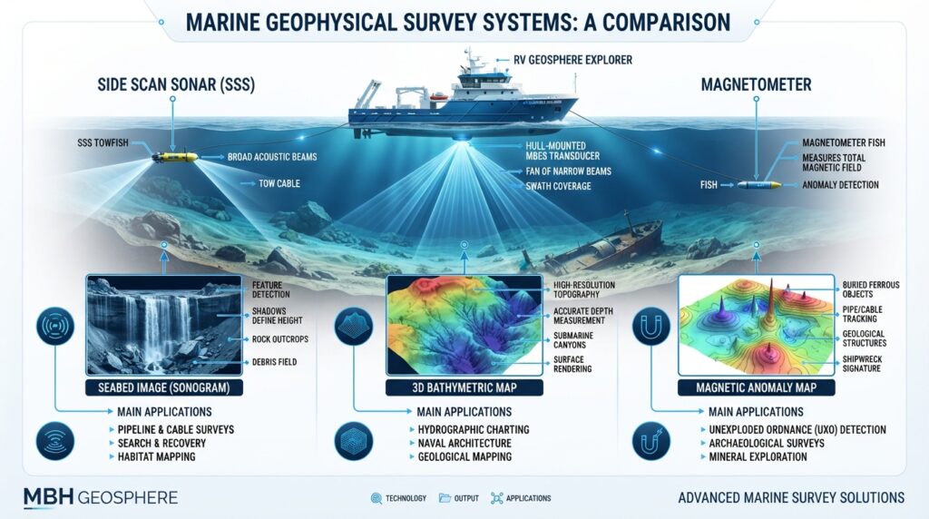
Feature Side Scan Sonar Multibeam Echo Sounder Main Purpose Seabed Imaging Water Depth Measurement Output High-Resolution Images Bathymetric Map Detects Objects Excellent Good Measures Depth No Yes 3D Seabed Model No Yes Best For Object Detection Seabed Mapping
Side Scan Sonar vs Magnetometer
| Feature | Side Scan Sonar | Magnetometer |
|---|---|---|
| Detects Visible Objects | Yes | No |
| Detects Buried Metal Objects | Limited | Yes |
| Uses Sound Waves | Yes | No |
| Measures Magnetic Field | No | Yes |
| Best For | Seabed Images | Buried Metal Detection |
Real-World Example
Imagine a company plans to install a new underwater pipeline.
Before construction starts, surveyors first scan the area using a Side Scan Sonar.
The sonar images reveal an old anchor, several large rocks, and a small shipwreck along the planned route.
Engineers then adjust the pipeline route to avoid these obstacles, reducing construction risks and saving time.
This is one of the main reasons why Side Scan Sonar is an essential tool in offshore engineering projects.
Why Engineers Use Side Scan Sonar
Engineers choose Side Scan Sonar because it provides a clear picture of the seabed before work begins.
It helps them:
- Make better decisions
- Improve project safety
- Reduce unexpected delays
- Save survey costs
- Protect underwater infrastructure
Related Equipment
You may also be interested in:
- Magnetometer
- Sub Bottom Profiler
- Multibeam Echo Sounder (MBES)
- Single Beam Echo Sounder (SBES)
- ADCP
- Survey Vessel
- Uncrewed Surface Vessel (USV)
Frequently Asked Questions (FAQs)
What is Side Scan Sonar?
A Side Scan Sonar is an underwater survey system that uses sound waves to create detailed images of the seabed. It helps surveyors locate underwater objects such as pipelines, shipwrecks, cables, rocks, and debris.
What is Side Scan Sonar used for?
It is used in hydrographic and geophysical surveys to inspect the seabed before marine construction, dredging, pipeline installation, and offshore projects.
Does Side Scan Sonar measure water depth?
No. Side Scan Sonar creates images of the seabed but does not directly measure water depth. For depth measurements, surveyors use a Single Beam Echo Sounder (SBES) or a Multibeam Echo Sounder (MBES).
Can Side Scan Sonar detect buried pipelines?
It can detect pipelines that are exposed on the seabed. If a pipeline is completely buried beneath the seabed, a Sub Bottom Profiler (SBP) or Magnetometer is usually required.
What is the difference between Side Scan Sonar and Multibeam Echo Sounder?
Side Scan Sonar creates detailed images of the seabed, while a Multibeam Echo Sounder measures water depth and produces a 3D bathymetric map.
Can Side Scan Sonar work in shallow water?
Yes. It can be used in both shallow and deep water. The survey setup depends on the water depth and project requirements.
Is Side Scan Sonar used with a USV?
Yes. Many modern Side Scan Sonar systems can be installed on an Uncrewed Surface Vessel (USV) for safe and efficient surveys.
How accurate is Side Scan Sonar?
The quality of the images depends on factors such as sonar frequency, survey speed, towfish height, and water conditions. When used correctly, it provides very detailed seabed images.
Maintenance Tips
Regular maintenance helps improve survey quality and extends the life of the equipment.
- Wash the towfish with fresh water after every survey.
- Inspect the tow cable for damage before deployment.
- Clean the sonar connectors regularly.
- Store the equipment in a dry and safe location.
- Check GNSS and communication connections before each survey.
- Update the survey software when new versions are available.
- Perform system calibration according to the manufacturer’s recommendations.
Safety Tips
Following basic safety practices helps protect both the equipment and the survey team.
- Check weather and sea conditions before starting the survey.
- Keep the towfish at a safe distance from the vessel.
- Avoid towing the sonar over known obstacles.
- Monitor the tow cable during turns.
- Wear appropriate personal protective equipment (PPE) during deployment and recovery.
- Back up survey data regularly during the project.
Common Survey Challenges
During a Side Scan Sonar survey, engineers may face some common challenges.
| Challenge | Solution |
|---|---|
| Poor image quality | Reduce survey speed and adjust towfish height. |
| Communication problems | Check cables, connectors, and power supply. |
| Noisy sonar images | Move away from vessel propeller turbulence and electrical interference. |
| Incomplete coverage | Plan survey lines with sufficient overlap. |
| Incorrect positioning | Verify GNSS settings and antenna offsets. |
Best Practices
To achieve the best survey results:
- Plan the survey area carefully.
- Use accurate GNSS positioning.
- Maintain a constant vessel speed.
- Monitor sonar images in real time.
- Record notes during the survey.
- Review data quality before leaving the survey site.
- Process the data using professional hydrographic software.