
Sub Bottom Profiler (SBP)
See What Is Hidden Beneath the Seabed
Introduction
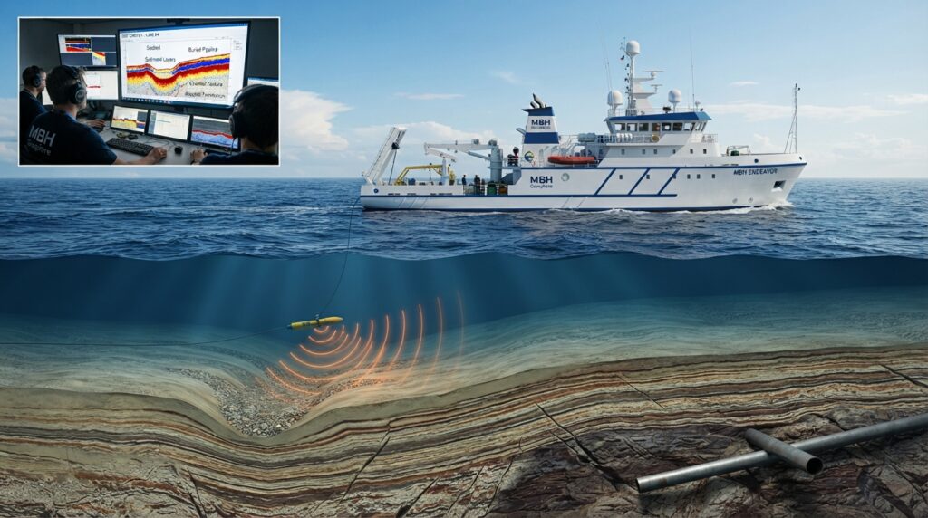
When engineers plan an offshore project, they need more than a map of the seabed. They also need to know what lies below the seabed.
A Sub Bottom Profiler (SBP) is a marine survey system that uses sound waves to look beneath the seabed surface. It helps surveyors identify sediment layers, buried objects, old river channels, and underground features that cannot be seen with normal sonar systems.
Sub Bottom Profiler surveys are widely used before offshore construction, pipeline installation, cable laying, dredging, and marine engineering projects. The collected information helps engineers make better design decisions and reduces construction risks.
What is a Sub Bottom Profiler?
A Sub Bottom Profiler (SBP) is an acoustic survey system that creates images of the layers beneath the seabed.
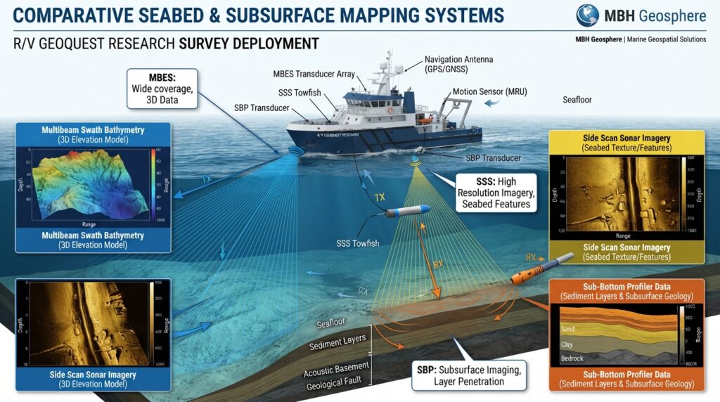
Unlike a Side Scan Sonar, which shows what is lying on the seabed, or a Multibeam Echo Sounder, which measures water depth, a Sub Bottom Profiler looks below the seabed surface.
It helps surveyors understand the thickness and structure of sediments and locate buried features.
Why is a Sub Bottom Profiler Important?
Many offshore projects depend on the strength and condition of the seabed.
Before installing pipelines, submarine cables, offshore platforms, or wind turbines, engineers need to know:
- How thick are the sediment layers?
- Is there hard rock below the seabed?
- Are there buried channels?
- Are there buried pipelines or objects?
- Is the ground suitable for construction?
A Sub Bottom Profiler provides this information without digging into the seabed.
Where is a Sub Bottom Profiler Used?
Sub Bottom Profilers are commonly used for:
- Geophysical Surveys
- Offshore Oil and Gas Projects
- Pipeline Route Surveys
- Cable Route Surveys
- Offshore Wind Farm Projects
- Port Development
- Harbor Construction
- Dredging Projects
- Marine Archaeology
- Environmental Studies
- Coastal Engineering
- Scientific Research
Quick Facts
| Feature | Details |
|---|---|
| Full Name | Sub Bottom Profiler |
| Short Name | SBP |
| Technology | Acoustic Survey |
| Main Purpose | Image Layers Below the Seabed |
| Platform | Survey Vessel or USV |
| Output | Seabed Layer Profile |
| Common Users | Marine Survey Engineers & Geophysicists |
Did You Know?
A Sub Bottom Profiler can reveal sediment layers and buried features several meters below the seabed, depending on the equipment type and seabed conditions. This information is important for safe offshore construction and marine engineering.
How Does a Sub Bottom Profiler Work?
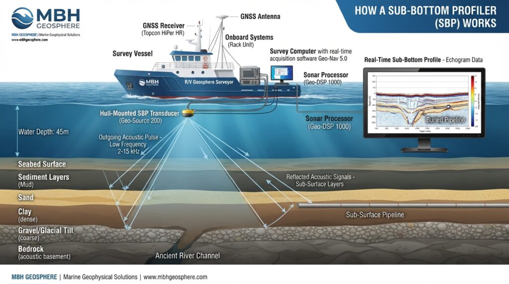
A Sub Bottom Profiler (SBP) uses low-frequency sound waves to look beneath the seabed.
The system sends acoustic pulses from the survey vessel into the water. These sound waves pass through the water and penetrate the seabed. As they travel through different sediment layers, part of the sound is reflected back to the receiver.
The returned signals are processed by the survey computer to create a vertical profile showing the different layers below the seabed.
This profile helps engineers understand what is hidden beneath the surface without digging or drilling.
Step-by-Step Working Process
Step 1 – Survey Planning
Before the survey starts, engineers define the survey area and create survey lines using hydrographic or geophysical survey software.
The survey plan depends on the project requirements and the area to be investigated.
Step 2 – Equipment Installation
The Sub Bottom Profiler transducer is installed on the survey vessel or mounted on a pole or hull.
The system is connected to:
- GNSS Receiver
- Survey Computer
- Data Acquisition Software
- Power Supply
All equipment is checked before starting the survey.
Step 3 – Acoustic Pulse Transmission
The transducer sends low-frequency sound waves toward the seabed.
These sound waves are strong enough to pass through soft sediments below the seabed.
Step 4 – Sound Reflection
Whenever the sound waves reach a different sediment layer or a buried object, part of the energy reflects back toward the receiver.
Different materials produce different reflections.
For example:
- Soft mud
- Sand
- Clay
- Gravel
- Rock
- Buried pipeline
Each material creates a different signal.
Step 5 – Data Collection
The reflected signals are recorded together with the vessel’s exact position.
The GNSS receiver ensures every profile is stored at the correct location.
Step 6 – Data Processing
The collected data is processed using geophysical software.
The software creates a continuous underground profile showing:
- Sediment layers
- Buried objects
- Geological formations
- Underground features
Engineers study these profiles before making construction decisions.
Main Components of a Sub Bottom Profiler System
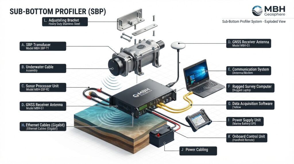
A complete Sub Bottom Profiler system consists of several important parts.
Sub Bottom Profiler Transducer
The transducer is the main sensor.
It sends acoustic pulses into the seabed and receives the returning echoes.
Sonar Processor
The processor converts the returning signals into readable survey data.
It improves signal quality before displaying the results.
GNSS Receiver
The GNSS receiver records the exact position of every survey line.
This ensures all underground features are mapped accurately.
Survey Computer
The survey computer displays the underground profile in real time.
It also stores all survey data for processing.
Survey Software
The software processes the recorded data and creates detailed sub-bottom profiles.
Engineers use these profiles to analyze the seabed layers.
Power Supply
The power system provides stable electricity to all survey equipment during the survey.
Types of Sub Bottom Profilers
Different projects require different Sub Bottom Profiler systems.
Chirp Sub Bottom Profiler
A Chirp system uses a wide range of frequencies to produce high-resolution images of shallow sediment layers.
Best for:
- Harbor Surveys
- Coastal Surveys
- Pipeline Surveys
- Environmental Studies
Boomer System
Boomer systems produce stronger acoustic signals that can penetrate deeper into the seabed.
Best for:
- Offshore Engineering
- Port Development
- Deep Sediment Investigation
Sparker System
A Sparker system generates powerful electrical pulses to investigate deep geological layers.
Best for:
- Oil & Gas Exploration
- Deep Offshore Projects
- Geological Studies
Pinger System
A Pinger uses higher frequencies and provides very detailed images of shallow sediments.
Best for:
- Shallow Water Surveys
- Scientific Research
- Environmental Monitoring
Typical Technical Specifications
| Feature | Typical Value |
|---|---|
| Technology | Acoustic Profiling |
| Frequency Range | 2–20 kHz (Model Dependent) |
| Penetration Depth | Up to 100 meters (Depends on Sediment) |
| Platform | Survey Vessel / USV |
| Positioning | GNSS / RTK |
| Output | Sub-bottom Profile Images |
| Data Format | SEG-Y, XTF, Manufacturer Formats |
Typical Survey Workflow
A Sub Bottom Profiler survey normally follows these steps:
- Project Planning
- Equipment Installation
- GNSS Configuration
- System Calibration
- Survey Data Collection
- Quality Control
- Data Processing
- Profile Interpretation
- Final Survey Report
Best Survey Practices
For accurate survey results:
- Plan survey lines carefully.
- Maintain a constant vessel speed.
- Monitor signal quality during the survey.
- Check GNSS positioning regularly.
- Avoid electrical interference.
- Review profiles before leaving the survey area.
- Back up survey data after each survey.
Applications of a Sub Bottom Profiler
A Sub Bottom Profiler (SBP) is used in many marine projects where engineers need to understand what lies beneath the seabed. It provides valuable information about underground layers, buried objects, and geological features before construction begins.
Below are the most common applications.
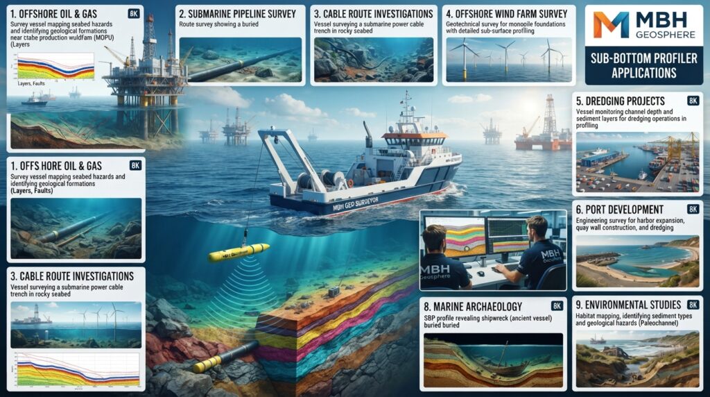
Offshore Oil and Gas Projects
Before drilling or installing offshore structures, engineers need to know the condition of the seabed and the layers below it.
A Sub Bottom Profiler helps identify soft sediments, hard rock, buried channels, and other underground features that may affect construction.
Pipeline Route Surveys
Before laying a subsea pipeline, surveyors use a Sub Bottom Profiler to study the ground beneath the seabed.
The survey helps engineers choose a stable route and avoid weak sediments or buried obstacles.
Submarine Cable Route Surveys
Communication and power cables often need to be buried below the seabed for protection.
A Sub Bottom Profiler helps determine the best cable route by showing sediment thickness and underground conditions.
Offshore Wind Farm Projects
Wind turbine foundations require stable ground.
Engineers use a Sub Bottom Profiler to examine sediment layers and identify suitable foundation locations before installation.
Port and Harbor Development
When expanding or building a port, engineers must understand the underground soil conditions.
A Sub Bottom Profiler provides important information for dredging, quay wall construction, and foundation design.
Dredging Projects
A Sub Bottom Profiler is commonly used before dredging begins.
It helps determine:
- Thickness of soft sediments
- Depth of hard layers
- Buried debris
- Existing underground structures
This information helps estimate dredging volumes and choose the correct equipment.
Marine Archaeology
Marine archaeologists use Sub Bottom Profilers to search for buried historical objects without disturbing the seabed.
The system can help locate:
- Ancient shipwrecks
- Buried wooden structures
- Old river channels
- Historical settlements beneath coastal sediments
Environmental Studies
Scientists use Sub Bottom Profilers to study sediment accumulation, erosion, and changes in the seabed over time.
This information supports coastal management and environmental protection projects.
Coastal Engineering
Before building seawalls, breakwaters, jetties, or artificial islands, engineers investigate the underground soil conditions using a Sub Bottom Profiler.
This helps reduce construction risks and improve foundation design.
Advantages of a Sub Bottom Profiler
A Sub Bottom Profiler offers several important benefits for marine engineering projects.
- Shows layers beneath the seabed without drilling.
- Detects buried objects and underground features.
- Helps engineers choose safe construction locations.
- Reduces project risks.
- Supports better foundation design.
- Provides continuous underground profiles.
- Covers large survey areas efficiently.
- Works well with other survey systems such as Side Scan Sonar and Multibeam Echo Sounders.
Limitations of a Sub Bottom Profiler
Although it is a powerful survey tool, it also has some limitations.
- Penetration depth depends on seabed material.
- Hard rock may reduce signal penetration.
- Rough sea conditions can affect data quality.
- Requires experienced personnel to interpret profiles.
- Cannot replace borehole investigations when detailed soil samples are needed.
Popular Sub Bottom Profiler Models
Some widely used models include:
- EdgeTech 3200 Series
- EdgeTech DW-216
- Innomar SES-2000 Series
- Teledyne Benthos Chirp III
- GeoAcoustics GeoPulse
- SyQwest Stratabox
Sub Bottom Profiler vs Side Scan Sonar
| Feature | Sub Bottom Profiler | Side Scan Sonar |
|---|---|---|
| Main Purpose | Image layers below the seabed | Create images of the seabed surface |
| Technology | Low-frequency acoustic waves | High-frequency acoustic waves |
| Shows Buried Layers | Yes | No |
| Shows Surface Objects | Limited | Excellent |
| Best Use | Underground investigation | Seabed object detection |
Sub Bottom Profiler vs Multibeam Echo Sounder
| Feature | Sub Bottom Profiler | Multibeam Echo Sounder |
|---|---|---|
| Main Purpose | Investigate subsurface layers | Measure water depth |
| Output | Vertical subsurface profile | 3D bathymetric map |
| Penetrates Seabed | Yes | No |
| Measures Water Depth | No | Yes |
| Best Use | Geotechnical & geophysical surveys | Hydrographic mapping |
Real-World Example
An engineering company is planning to install an offshore wind farm.
A Multibeam Echo Sounder is first used to map the seabed, while a Side Scan Sonar checks for rocks, debris, and existing pipelines.
Next, a Sub Bottom Profiler investigates the sediment layers beneath the seabed. The survey shows that one part of the site has soft clay, while another area has dense sand and gravel.
Based on this information, engineers choose the stronger ground for the turbine foundations. This improves safety, reduces construction risks, and helps avoid costly design changes later.
Why Engineers Use a Sub Bottom Profiler
Engineers use a Sub Bottom Profiler because it provides important information that cannot be seen from the seabed surface.
It helps them:
- Understand underground soil conditions.
- Plan safe offshore construction.
- Select suitable foundation locations.
- Identify buried channels and objects.
- Reduce unexpected ground-related problems.
- Improve project planning and decision-making.
Related Equipment
To complete a marine geophysical survey, a Sub Bottom Profiler is often used together with:
- Side Scan Sonar (SSS)
- Multibeam Echo Sounder (MBES)
- Single Beam Echo Sounder (SBES)
- Magnetometer
- Acoustic Doppler Current Profiler (ADCP)
- GNSS Receiver
- Survey Vessel
- Uncrewed Surface Vessel (USV)
Frequently Asked Questions (FAQs)
What is a Sub Bottom Profiler?
A Sub Bottom Profiler (SBP) is a marine survey system that uses low-frequency sound waves to create images of the layers beneath the seabed. It helps engineers understand underground conditions before offshore construction and marine projects.
What is a Sub Bottom Profiler used for?
A Sub Bottom Profiler is used to investigate the layers below the seabed. It is commonly used for offshore construction, pipeline route surveys, cable route surveys, dredging projects, offshore wind farms, marine archaeology, and environmental studies.
Can a Sub Bottom Profiler detect buried pipelines?
Yes. A Sub Bottom Profiler can detect buried pipelines, cables, old channels, and other underground features when the burial depth and seabed conditions are suitable.
How deep can a Sub Bottom Profiler scan?
The penetration depth depends on the equipment model, operating frequency, and seabed material. In soft sediments, many systems can investigate tens of meters below the seabed.
Does a Sub Bottom Profiler measure water depth?
No. A Sub Bottom Profiler is designed to investigate the layers beneath the seabed. Water depth is normally measured using a Single Beam Echo Sounder (SBES) or a Multibeam Echo Sounder (MBES).
What is the difference between a Sub Bottom Profiler and Side Scan Sonar?
A Side Scan Sonar creates detailed images of the seabed surface, while a Sub Bottom Profiler shows the layers and features hidden beneath the seabed.
Can a Sub Bottom Profiler be installed on a USV?
Yes. Many modern Sub Bottom Profiler systems can be installed on Uncrewed Surface Vessels (USVs), making surveys safer and more efficient in shallow or hazardous areas.
Why is a Sub Bottom Profiler important?
It helps engineers understand underground conditions before construction, reducing project risks and supporting better engineering decisions.
Maintenance Tips
Regular maintenance improves performance and extends the life of the equipment.
- Rinse the transducer with fresh water after each survey.
- Inspect all cables and connectors before every project.
- Keep the transducer clean to maintain signal quality.
- Store equipment in a dry and dust-free environment.
- Check GNSS and communication systems before starting a survey.
- Update firmware and software when recommended by the manufacturer.
- Perform routine system checks and calibration.
Safety Tips
Following safe working practices helps protect the survey team and equipment.
- Check weather and sea conditions before deployment.
- Secure all equipment on the survey vessel.
- Follow safe lifting procedures when handling heavy equipment.
- Wear appropriate Personal Protective Equipment (PPE).
- Keep electrical connections dry and protected.
- Back up survey data during and after each survey.
- Stop operations if weather conditions become unsafe.
Common Survey Challenges
| Challenge | Solution |
|---|---|
| Weak penetration into the seabed | Use a lower-frequency system or adjust survey settings. |
| Poor profile quality | Reduce vessel speed and check transducer alignment. |
| High background noise | Inspect cables, electrical connections, and interference sources. |
| Incorrect positioning | Verify GNSS settings and antenna offsets before surveying. |
| Missing survey lines | Plan adequate overlap and monitor data coverage during the survey. |
Best Survey Practices
For reliable survey results:
- Plan survey lines before starting.
- Maintain a constant vessel speed.
- Monitor data quality in real time.
- Record environmental conditions during the survey.
- Check equipment calibration regularly.
- Review data before leaving the survey area.
- Process and back up survey data immediately after the survey.