
Acoustic Doppler Current Profiler (ADCP)
Measuring Water Currents with High Accuracy
Introduction
Water is always moving. Rivers flow continuously, tides change throughout the day, and ocean currents travel across large distances. Understanding how water moves is essential for marine engineering, navigation, environmental studies, and offshore construction.
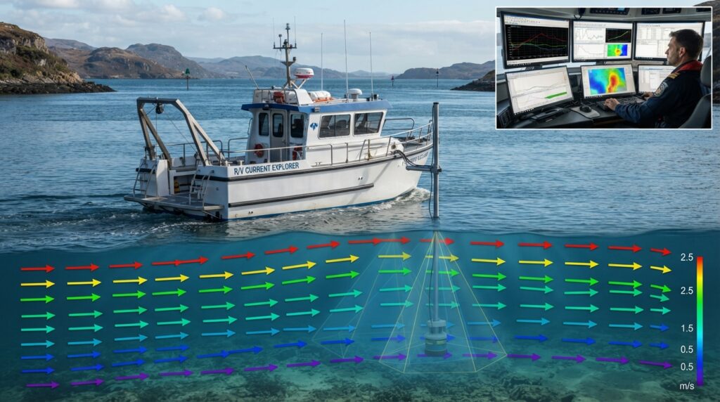
An Acoustic Doppler Current Profiler (ADCP) is a professional survey instrument that measures the speed and direction of moving water. Instead of measuring only the surface, an ADCP collects current data throughout the entire water column, from near the surface to close to the seabed.
Today, ADCP systems are widely used by hydrographic surveyors, oceanographers, environmental scientists, and offshore engineers. The collected information helps improve project planning, navigation safety, coastal management, flood studies, and marine research.
What is an Acoustic Doppler Current Profiler?
An Acoustic Doppler Current Profiler, commonly called an ADCP, is an acoustic instrument that measures water current velocity using sound waves.
The instrument sends high-frequency acoustic pulses into the water. Small particles naturally suspended in the water reflect these sound waves back to the instrument. By measuring the change in frequency of the returned signal, known as the Doppler Effect, the ADCP calculates both the speed and direction of the moving water.
Unlike traditional current meters that measure water movement at only one location, an ADCP measures water currents at multiple depths simultaneously. This creates a complete profile of water movement through the entire water column.
Why is ADCP Important?
Accurate current information is essential before many marine projects begin.
Strong currents can affect survey accuracy, vessel operations, dredging activities, offshore construction, bridge construction, and underwater installations.
An ADCP helps engineers understand how water behaves under different tidal and weather conditions. This information improves engineering design, increases operational safety, and reduces project risks.
Because currents change throughout the day, long-term ADCP measurements provide valuable information for planning marine operations at the safest and most efficient times.
Where is ADCP Used?
Hydrographic Surveys
ADCP is widely used during hydrographic surveys to measure water current velocity before collecting bathymetric data. Understanding the current helps surveyors plan safe and accurate survey operations.
River Surveys
River engineers use ADCP systems to measure river flow, discharge, and current speed. The collected data supports bridge design, flood studies, river management, and environmental monitoring.
Offshore Oil and Gas Projects
Offshore construction requires detailed knowledge of current conditions. ADCP surveys help engineers design offshore platforms, pipelines, subsea structures, and safe installation procedures.
Offshore Wind Farms
Before installing offshore wind turbines, engineers study water currents to understand environmental conditions around the proposed site.
Port and Harbor Engineering
Current measurements help improve navigation safety and support the design of ports, harbors, navigation channels, and breakwaters.
Dredging Projects
Water currents influence sediment movement during dredging operations. ADCP data helps engineers monitor these changes and improve dredging efficiency.
Environmental Monitoring
Scientists use ADCP data to study water circulation, sediment transport, coastal erosion, and aquatic ecosystems.
Scientific Research
Universities and research organizations use ADCP systems to study rivers, lakes, estuaries, and oceans for long-term environmental monitoring.
Quick Facts
| Feature | Details |
|---|---|
| Full Name | Acoustic Doppler Current Profiler |
| Short Name | ADCP |
| Technology | Acoustic Doppler Measurement |
| Main Purpose | Measure Water Current Velocity |
| Platform | Survey Vessel, USV, Fixed Frame, Seabed |
| Output | Current Speed and Direction |
| Common Users | Hydrographic Surveyors, Oceanographers, Marine Engineers |
Did You Know?
A modern Acoustic Doppler Current Profiler can measure water currents at dozens or even hundreds of different depth cells at the same time, providing a complete picture of water movement from the surface to the seabed.
How Does an Acoustic Doppler Current Profiler Work?
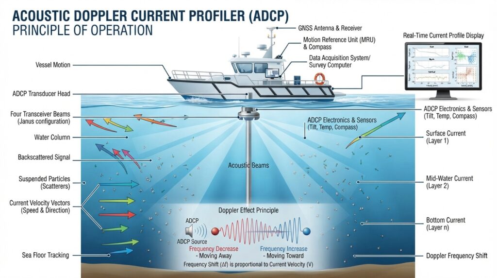
An Acoustic Doppler Current Profiler (ADCP) measures the speed and direction of moving water by using sound waves. Instead of placing sensors throughout the water, the ADCP sends acoustic pulses into the water column and listens for the echoes that return from tiny suspended particles such as sediment, plankton, and other natural materials.
As these particles move with the current, the frequency of the reflected sound changes slightly. This change is called the Doppler Effect. By analyzing this change, the ADCP calculates the speed and direction of the water at different depths.
Unlike traditional current meters that measure water movement at only one point, an ADCP divides the water column into many measurement layers called depth cells or bins. This allows engineers to see how currents change from the surface to the seabed.
The Doppler Effect
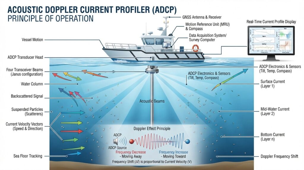
The Doppler Effect is the scientific principle that allows an ADCP to measure water movement.
When a sound wave reflects from a moving object, its frequency changes. If the particles in the water move toward the ADCP, the returned frequency becomes slightly higher. If they move away, the returned frequency becomes slightly lower.
The ADCP measures this small frequency difference and converts it into water current speed and direction. This process happens thousands of times every second, producing highly accurate current measurements.
How an ADCP Survey is Performed
Every ADCP survey begins with careful planning. Engineers first define the survey area and determine whether the instrument will be mounted on a survey vessel, an Uncrewed Surface Vessel (USV), a fixed frame, or the seabed.
Before deployment, the ADCP is connected to a GNSS receiver, survey computer, power supply, and data acquisition software. The communication between all devices is checked to ensure that positioning and current measurements are synchronized.
Once the survey begins, the ADCP continuously transmits acoustic pulses into the water. The reflected signals are received and processed in real time while the GNSS receiver records the exact location of every measurement.
During the survey, engineers monitor current profiles, instrument status, and data quality on the survey computer. After the survey is completed, the recorded data is processed using hydrographic software to create current profile charts, velocity plots, and engineering reports.a
Main Components of an ADCP System
ADCP Transducer
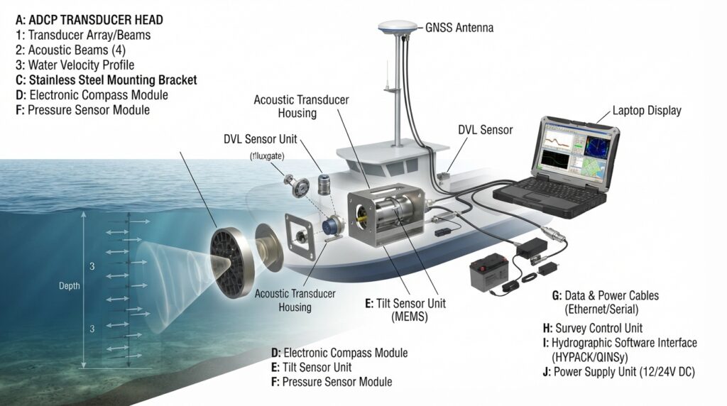
The transducer is the main part of the system. It sends acoustic signals into the water and receives the returning echoes. Modern ADCPs usually have three or four acoustic beams that measure water movement from different directions.
Acoustic Beams
The acoustic beams travel through the water column and measure the movement of suspended particles. Using multiple beams allows the ADCP to calculate the three-dimensional movement of water with high accuracy.
GNSS Receiver
The GNSS receiver records the precise position of the survey vessel or deployment platform. Accurate positioning ensures that every current measurement is linked to the correct location.
Compass
The electronic compass measures the heading of the instrument. This information allows the ADCP to calculate the true direction of the water current.
Tilt Sensor
The tilt sensor monitors the pitch and roll of the instrument. These measurements help correct the current data if the vessel or instrument moves during the survey.
Pressure Sensor
Many ADCP systems include a pressure sensor that measures water depth and helps determine the instrument’s position below the water surface.
Survey Computer
The survey computer controls the ADCP, displays live current profiles, stores survey data, and allows engineers to monitor system performance throughout the survey.
Data Acquisition Software
The software receives raw measurements from the ADCP, processes the information, and displays current speed, current direction, water depth, and other survey data in real time.
Power Supply
The power system provides continuous electrical power to the ADCP and supporting equipment during the survey.
Types of ADCP
Different projects require different ADCP configurations depending on the survey environment.
Vessel-Mounted ADCP
A vessel-mounted ADCP is installed directly on a survey boat. It measures water currents while the vessel is moving and is commonly used for hydrographic surveys, river studies, and discharge measurements.
Bottom-Mounted ADCP
A bottom-mounted ADCP is placed on the seabed or riverbed and collects current measurements continuously for several days, weeks, or even months. This type is widely used for long-term environmental monitoring.
Side-Mounted ADCP
A side-mounted ADCP is attached to the side of a survey vessel using a mounting pole. This installation method is commonly used for temporary surveys.
USV-Mounted ADCP
Modern Uncrewed Surface Vessels (USVs) can carry compact ADCP systems. This allows current measurements to be collected safely in shallow water or hazardous areas without placing people at risk.
Typical Technical Specifications
| Feature | Typical Value |
|---|---|
| Technology | Acoustic Doppler Measurement |
| Operating Frequency | 300 kHz to 1200 kHz (Model Dependent) |
| Measurement Range | Depends on Frequency and Water Depth |
| Current Velocity Accuracy | Approximately ±0.5% of Measured Velocity |
| Positioning | GNSS / RTK |
| Deployment Platform | Vessel, USV, Seabed, Fixed Frame |
| Data Output | Current Speed, Direction and Water Profile |
| Communication | Ethernet, Serial, Wi-Fi (Model Dependent) |
Why Accurate Current Data Matters
Water currents influence almost every marine operation. Strong currents can affect survey accuracy, vessel navigation, dredging efficiency, underwater construction, and offshore installation work.
By measuring current speed and direction throughout the entire water column, an ADCP helps engineers understand changing water conditions before making important operational decisions. Reliable current information improves safety, reduces delays, and supports better engineering design.
Applications of an Acoustic Doppler Current Profiler
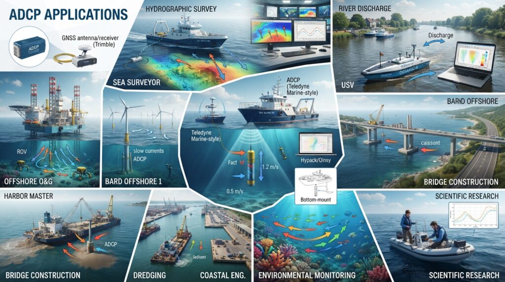
An Acoustic Doppler Current Profiler (ADCP) is one of the most widely used instruments in hydrographic and oceanographic surveys. It provides accurate information about water movement, helping engineers, scientists, and environmental specialists understand how currents behave in rivers, lakes, estuaries, and oceans.
Hydrographic Surveys
ADCP is an essential instrument during hydrographic surveys. It measures current speed and direction throughout the water column, allowing surveyors to understand water movement before collecting bathymetric data. This information improves survey planning and helps produce more reliable results.
River Discharge Measurement
River authorities and water resource engineers use ADCP systems to calculate river discharge. By measuring both water velocity and river cross-sectional area, the instrument provides accurate flow calculations that support flood forecasting, irrigation planning, and water resource management.
Offshore Oil and Gas Projects
Current measurements are important before installing offshore platforms, subsea pipelines, and underwater structures. ADCP surveys help engineers understand current conditions that may affect offshore construction, diving operations, and subsea equipment installation.
Offshore Wind Farm Development
Before offshore wind turbines are installed, engineers study current conditions to design stable foundations and plan safe installation activities. Long-term ADCP measurements also support maintenance planning after the wind farm becomes operational.
Port and Harbor Engineering
Ports and harbors experience changing tidal currents every day. ADCP data helps engineers improve navigation safety, design navigation channels, and understand sediment movement within the harbor.
Bridge Construction
When bridges are constructed across rivers or coastal waters, engineers use ADCP surveys to measure water currents around bridge piers. This information supports foundation design and helps reduce the risk of erosion around the structure.
Dredging Projects
Water currents affect how sediment moves before, during, and after dredging. ADCP measurements help engineers monitor these changes, improve dredging efficiency, and evaluate project performance.
Environmental Monitoring
Environmental agencies use ADCP systems to study water circulation, sediment transport, pollution movement, and ecosystem changes. Long-term monitoring helps scientists understand seasonal and environmental variations.
Coastal Engineering
Coastal engineers use ADCP data to study tidal currents and shoreline processes. The information supports the design of seawalls, breakwaters, ports, and coastal protection structures.
Scientific Research
Universities and research organizations use ADCP systems to study rivers, lakes, estuaries, and oceans. The collected data improves understanding of water circulation, climate, and marine environments.
Advantages of an ADCP
An Acoustic Doppler Current Profiler provides accurate current measurements throughout the entire water column instead of measuring only one location. This allows engineers to understand how water movement changes with depth.
The instrument collects large amounts of data in a short time, making surveys faster and more efficient. Modern ADCP systems can operate from survey vessels, uncrewed surface vessels, fixed frames, or the seabed, making them suitable for many different projects.
Because the system uses acoustic technology, there is no need for moving mechanical parts inside the water. This improves reliability and reduces maintenance requirements.
The collected data supports safer offshore operations, better engineering design, improved navigation, and more accurate environmental studies.
Limitations of an ADCP
Although an ADCP is highly accurate, some conditions can reduce measurement quality.
Very shallow water may limit the measurement range because the instrument requires enough depth for acoustic profiling.
High concentrations of air bubbles, heavy vegetation, or excessive underwater noise can affect acoustic signals and reduce data quality.
Strong vessel movement during rough weather may introduce additional corrections during data processing.
Regular calibration and proper installation are important to achieve the best measurement accuracy.
Major Manufacturers
Several international companies manufacture professional ADCP systems used by hydrographic surveyors and marine engineers around the world.
Leading manufacturers include Teledyne RD Instruments, Nortek, SonTek (Xylem), Rowe Technologies, LinkQuest, Aanderaa, Sea-Bird Scientific, and RBR.
These companies supply ADCP systems for hydrographic surveys, offshore energy, environmental monitoring, scientific research, and water resource management.
Popular ADCP Models
Some of the most widely used ADCP models include the Teledyne WorkHorse Monitor ADCP, Teledyne RiverRay ADCP, Teledyne Rio Grande ADCP, Nortek Signature Series, Nortek Aquadopp Profiler, SonTek M9, SonTek RS5, and RoweSeaProfiler ADCP.
Each model is designed for different water depths, measurement ranges, and survey applications.
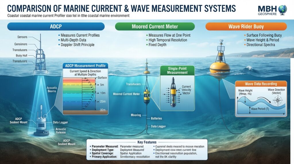
ADCP vs Current Meter
| Feature | ADCP | Current Meter |
|---|---|---|
| Main Purpose | Measures complete water current profile | Measures current at a single point |
| Measurement Area | Entire water column | One measurement location |
| Technology | Acoustic Doppler | Mechanical or Electromagnetic |
| Survey Speed | Fast | Slower |
| Data Output | Current profile at multiple depths | Single current reading |
| Best Use | Hydrographic and oceanographic surveys | Basic current monitoring |
ADCP vs Wave Rider Buoy
| Feature | ADCP | Wave Rider Buoy |
|---|---|---|
| Measures | Water Current | Ocean Waves |
| Installation | Vessel, Seabed or USV | Floating Buoy |
| Main Output | Current Speed and Direction | Wave Height, Period and Direction |
| Best Application | Current Analysis | Sea State Monitoring |
| Survey Type | Hydrographic Survey | Oceanographic Survey |
Real-World Example
A new bridge is planned across a large river.
Before construction begins, engineers deploy an Acoustic Doppler Current Profiler to measure water currents over several tidal cycles. The collected data shows that current speed increases significantly during the rainy season and becomes stronger near the proposed bridge piers.
Using this information, the design team strengthens the bridge foundations and adjusts the construction schedule to avoid periods of high river flow. This reduces construction risks, improves worker safety, and helps protect the structure throughout its service life.
Why Engineers Use an ADCP
Engineers use an Acoustic Doppler Current Profiler because it provides detailed information about water movement that cannot be obtained from simple surface observations.
The instrument helps improve project planning, supports safer marine operations, reduces engineering risks, and provides reliable data for design and environmental studies. Whether the project involves offshore construction, river engineering, dredging, or scientific research, ADCP measurements play an important role in making informed decisions.
Related Equipment
An Acoustic Doppler Current Profiler is commonly used together with Multibeam Echo Sounder (MBES), Single Beam Echo Sounder (SBES), Side Scan Sonar (SSS), Sub Bottom Profiler (SBP), Wave Rider Buoy, Tide Gauge, GNSS Receiver, Survey Vessel, and Uncrewed Surface Vessel (USV). Combining these systems provides a complete understanding of underwater conditions and marine environments.
Frequently Asked Questions
What is an Acoustic Doppler Current Profiler (ADCP)?
An Acoustic Doppler Current Profiler (ADCP) is a survey instrument that uses sound waves to measure the speed and direction of moving water. It creates a complete current profile from the water surface to the seabed, making it one of the most important instruments in hydrographic and oceanographic surveys.
What is an ADCP used for?
An ADCP is used to measure water currents in rivers, lakes, estuaries, reservoirs, coastal waters, and offshore environments. It supports hydrographic surveys, river discharge measurements, offshore construction, dredging projects, environmental studies, and scientific research.
How does an ADCP measure water currents?
The instrument transmits acoustic sound waves into the water. These sound waves reflect from tiny particles suspended in the water. By measuring the change in the returned sound frequency using the Doppler Effect, the ADCP calculates the speed and direction of the moving water.
Can an ADCP measure water depth?
Some ADCP systems can estimate water depth using echo sounding techniques, but their primary purpose is measuring water current velocity. For detailed bathymetric surveys, engineers normally use a Single Beam Echo Sounder (SBES) or a Multibeam Echo Sounder (MBES).
Where can an ADCP be installed?
An ADCP can be mounted on a survey vessel, an Uncrewed Surface Vessel (USV), a floating platform, a fixed frame, or directly on the seabed for long-term monitoring.
What is the difference between an ADCP and a Current Meter?
A traditional Current Meter measures water movement at a single point, while an ADCP measures current speed and direction throughout the entire water column, providing much more detailed information.
Can an ADCP work in rivers?
Yes. ADCP systems are widely used for river surveys because they measure current velocity, river discharge, and flow patterns quickly and accurately.
Why is ADCP important in hydrographic surveys?
Water currents affect survey accuracy, vessel movement, sediment transport, and offshore construction. ADCP measurements help engineers understand these conditions before making important operational decisions.
Maintenance
Regular maintenance keeps an ADCP operating accurately and extends its service life. The transducer should be cleaned after every survey to remove salt, mud, algae, and marine growth. All connectors and communication cables should be inspected for corrosion or physical damage before deployment. Batteries should be checked regularly to ensure sufficient power during long surveys.
The GNSS receiver, compass, tilt sensor, and pressure sensor should be calibrated according to the manufacturer’s recommendations. Survey software and instrument firmware should also be updated whenever new versions become available. After every survey, the equipment should be rinsed with fresh water, dried carefully, and stored in a clean, dry environment.
Safety Considerations
Safe operation begins before the survey starts. Engineers should check weather forecasts, tidal conditions, and current predictions before deploying the equipment. The ADCP must be mounted securely to prevent movement during data collection. All electrical connections should be protected from water, and personnel should wear appropriate personal protective equipment while installing or recovering the instrument.
During offshore operations, engineers should continuously monitor instrument status and communication with the survey computer. Survey data should be backed up regularly to avoid accidental loss.
Common Survey Challenges
Air bubbles created by vessel movement can reduce acoustic signal quality, especially in rough sea conditions. Very shallow water may limit the measurement range, while excessive underwater noise can interfere with acoustic signals. Incorrect compass calibration may affect current direction measurements, and inaccurate GNSS positioning can reduce the quality of the final survey results. Routine calibration, careful installation, and continuous quality checks help minimize these problems.
Best Survey Practices
The best survey results are achieved when the instrument is calibrated before deployment and all supporting equipment is tested carefully. Engineers should maintain a steady vessel speed during mobile surveys and monitor current profiles continuously while collecting data. Environmental conditions should be recorded throughout the survey, and all measurements should be reviewed before leaving the project area. After processing, the data should be archived securely for future reference and reporting.