
What is a Side Scan Sonar?
Capture Clear Images of the Seabed
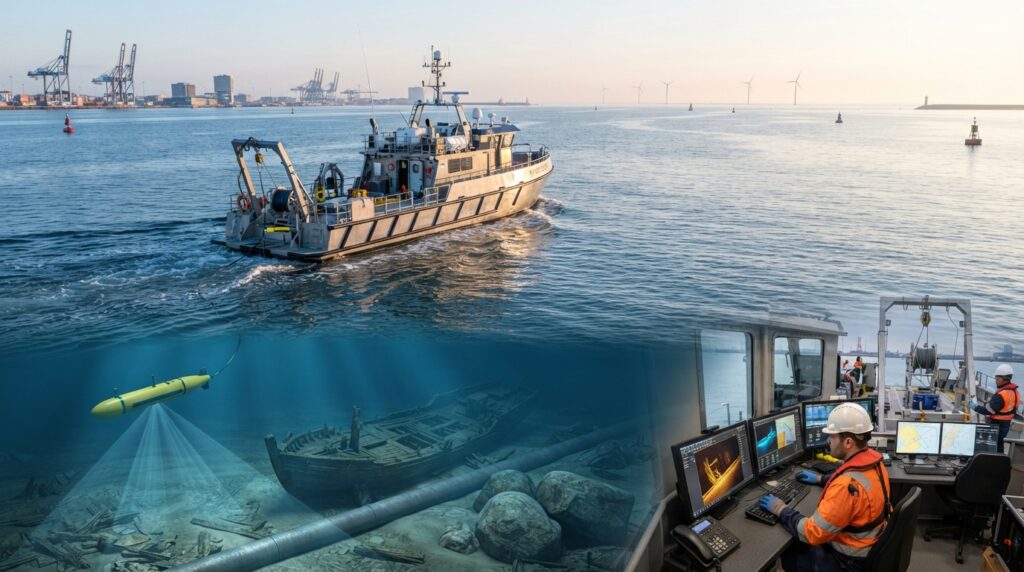
A Side Scan Sonar is an underwater imaging system that creates detailed pictures of the seabed. It helps surveyors detect shipwrecks, pipelines, cables, rocks, debris, and other underwater objects that may not be visible from the surface.
What is a Side Scan Sonar?
A Side Scan Sonar is a hydrographic survey instrument that uses sound waves to create detailed images of the seabed.
Instead of measuring only water depth, it scans both sides of the survey path and produces high-resolution images of underwater features. These images help surveyors understand what is lying on the seabed and identify objects that could affect marine operations.
A Side Scan Sonar is widely used in hydrographic surveys, marine construction, offshore projects, environmental studies, and underwater search operations.
Why is a Side Scan Sonar Important?
Many underwater objects cannot be seen from a boat because they are hidden beneath the water surface.
A Side Scan Sonar allows surveyors to detect shipwrecks, submerged rocks, pipelines, cables, anchors, debris, and other obstacles without sending divers into the water.
It provides valuable information that improves safety and supports better planning for marine engineering projects.
How Does a Side Scan Sonar Work?
A Side Scan Sonar is usually installed inside a towfish that is pulled behind a survey vessel.
As the towfish moves through the water, it sends sound waves to both the left and right sides of the survey line.
When the sound waves strike the seabed or an underwater object, they reflect back to the sonar.
The system processes these returning signals and creates detailed grayscale images of the seabed. Hard objects produce strong reflections, while soft seabed materials create weaker reflections.
These images help surveyors identify underwater features and objects with high accuracy.
Main Parts of a Side Scan Sonar System
A complete Side Scan Sonar system usually includes:
- Side Scan Sonar Towfish
- Tow Cable
- Hydraulic Winch
- Sonar Processor
- GNSS Receiver
- GNSS Antenna
- Survey Computer
- Side Scan Sonar Software
- Power Supply
- Survey Vessel
Each component works together to produce clear and accurate seabed images.
Where is a Side Scan Sonar Used?
A Side Scan Sonar is commonly used for:
- Hydrographic Surveys
- Seabed Mapping
- Shipwreck Detection
- Pipeline Inspection
- Cable Route Surveys
- Harbour Surveys
- Port Development
- Offshore Wind Farm Projects
- Oil and Gas Surveys
- Dredging Projects
- Search and Recovery Operations
- Marine Archaeology
- Environmental Surveys
Advantages of a Side Scan Sonar
A Side Scan Sonar provides clear images of the seabed, covers large survey areas quickly, detects small underwater objects, works in clear and muddy water, and reduces the need for underwater diving during inspections.
Side Scan Sonar vs Multibeam Echo Sounder
A Side Scan Sonar is mainly used to create detailed images of the seabed and locate underwater objects.
A Multibeam Echo Sounder is mainly used to measure water depth and produce accurate bathymetric maps.
Many hydrographic surveys use both systems together because they provide different types of information.
Common Applications
A Side Scan Sonar is widely used for:
- Shipwreck Surveys
- Pipeline Inspections
- Cable Inspections
- Seabed Clearance
- Harbour Surveys
- Dredging Support
- Offshore Engineering
- Marine Construction
- Search and Recovery
- Environmental Monitoring
Frequently Asked Questions
Can a Side Scan Sonar measure water depth?
Its main purpose is seabed imaging. Although it provides information about underwater features, accurate depth measurements are normally collected using a Single Beam or Multibeam Echo Sounder.
Can a Side Scan Sonar detect small objects?
Yes. Modern Side Scan Sonar systems can detect very small objects on the seabed when the survey is carried out correctly.
Can it work in muddy water?
Yes. Since it uses sound waves instead of light, it performs well even in muddy or low-visibility water.
Is a Side Scan Sonar used only in the sea?
No. It is also used in rivers, lakes, reservoirs, canals, harbours, and other inland waterways.
Conclusion
A Side Scan Sonar is one of the most valuable tools used in hydrographic surveying. It provides detailed images of the seabed and helps surveyors detect underwater objects quickly and safely. Its ability to reveal features that cannot be seen from the surface makes it an essential system for marine engineering, offshore projects, dredging, and underwater inspections.