
What is a Base Station?
The Starting Point of Every Accurate Survey
A Base Station is one of the most important parts of a modern survey. It is placed on a known location and sends correction data to survey receivers working in the field. These corrections improve positioning accuracy and help surveyors collect reliable measurements for construction, mapping, and engineering projects.
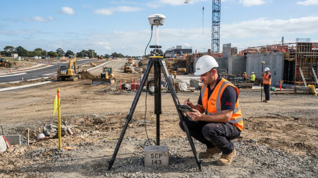
What is a Base Station?
A Base Station is a survey receiver that is placed on a point with known coordinates. It acts as a fixed reference point for the entire survey. While it stays in one position, it continuously receives signals from GNSS satellites and calculates correction data.
This correction data is sent to survey receivers, also called Rovers, working at different locations. The Rover uses these corrections to calculate a much more accurate position.
Without a Base Station, GNSS measurements may have errors of several meters. With correction data, the accuracy can improve to just a few centimeters.
Why is a Base Station Important?
Every survey project needs a reliable starting point. A Base Station provides that reference.
It helps surveyors collect accurate coordinates, reduce positioning errors, and keep all survey points connected to the same coordinate system.
This is why Base Stations are widely used in engineering, construction, mapping, and infrastructure projects.
How Does a Base Station Work?
A Base Station is installed on a control point with known coordinates.
After connecting to GNSS satellites, it compares its known position with the position calculated from the satellite signals.
If there is any difference, the Base Station calculates the error and creates correction data.
This correction data is then sent to the Rover through a radio signal or an internet connection.
The Rover applies these corrections instantly and calculates a much more accurate position.
Main Parts of a Base Station
A typical Base Station includes several important components.
- GNSS Receiver
- GNSS Antenna
- Survey Tripod
- Tribrach
- Battery or External Power Supply
- Radio Antenna or Internet Connection
- Survey Controller
Each component plays an important role in providing stable and accurate positioning.
Where is a Base Station Used?
Base Stations are used in many surveying and engineering projects.
Some common applications include:
- Land Surveying
- Construction Projects
- Road and Highway Surveys
- Railway Projects
- Topographic Surveys
- Utility Mapping
- Bridge Construction
- Mining
- Agriculture
- GIS Data Collection
- Infrastructure Development
Advantages of Using a Base Station
Using a Base Station offers many benefits.
It improves positioning accuracy, reduces survey errors, provides a reliable reference point, increases field productivity, and helps survey teams complete projects more efficiently.
It also ensures that all collected survey data follows the same coordinate system, making it easier to process and use later.
Base Station vs Rover
Many beginners confuse a Base Station with a Rover, but they have different jobs.
A Base Station stays at a fixed location and sends correction data.
A Rover moves around the survey area and uses those corrections to measure different points accurately.
Both work together to achieve precise survey results.
Common Applications
A Base Station is commonly used during:
- Control Surveys
- RTK Surveys
- Static GNSS Surveys
- Construction Layout
- Topographic Mapping
- Boundary Surveys
- Machine Control
- Drone Mapping
Frequently Asked Questions
Does a Base Station move during a survey?
No. A Base Station always remains at a fixed location throughout the survey.
Can a survey be completed without a Base Station?
Some surveys can be completed without one, but the accuracy is usually lower. For projects that require high precision, a Base Station is strongly recommended.
What accuracy can a Base Station provide?
When it is set up correctly and used with a compatible Rover, a Base Station can help achieve an accuracy of about 1 to 3 centimeters.
Does every survey need a Base Station?
Not every survey requires a Base Station. However, it is commonly used when high positioning accuracy is needed.
Conclusion
A Base Station is the foundation of an accurate GNSS survey. It provides correction data that helps surveyors reduce positioning errors and achieve reliable results. Whether the project involves construction, mapping, roads, or infrastructure, a properly configured Base Station plays an important role in collecting accurate and consistent survey data.