
What is a Sub Bottom Profiler?
See Beneath the Seabed Without Digging
A Sub Bottom Profiler (SBP) is a marine geophysical survey system that uses low-frequency sound waves to look below the seabed. It helps engineers and surveyors identify buried layers, pipelines, cables, rocks, and other underground features before construction begins.
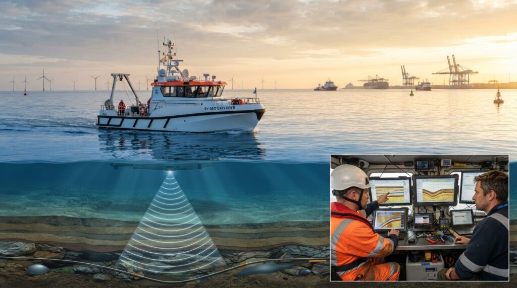
What is a Sub Bottom Profiler?
A Sub Bottom Profiler, commonly called an SBP, is a marine survey instrument that shows what is hidden beneath the seabed.
Unlike a Side Scan Sonar, which creates images of the seabed surface, a Sub Bottom Profiler looks below the seabed. It sends low-frequency acoustic pulses into the ground beneath the water. These sound waves travel through the sediment and reflect back whenever they reach a different underground layer.
The returned signals are processed by survey software to create a vertical cross-section of the seabed. This allows surveyors to study underground layers without digging or drilling.
Why is a Sub Bottom Profiler Important?
Many important features are buried beneath sand, mud, or sediment and cannot be seen from the surface.
A Sub Bottom Profiler helps engineers identify buried pipelines, old cables, hard rock layers, gas pockets, sediment thickness, and geological formations before starting marine construction.
This information reduces project risks, improves planning, and helps avoid costly delays.
How Does a Sub Bottom Profiler Work?
A Sub Bottom Profiler transducer is mounted on a survey vessel, pole, catamaran, or towed platform.
The system sends low-frequency acoustic pulses downward into the seabed.
As the sound waves travel through different sediment layers, part of the energy reflects back whenever the material changes.
The receiver collects these returning signals, and the survey software converts them into a vertical profile showing the different underground layers.
Surveyors use these profiles to understand the seabed structure and locate buried objects.
Main Parts of a Sub Bottom Profiler System
A complete SBP system usually includes:
- Sub Bottom Profiler Transducer
- Transceiver
- Power Unit
- GNSS Receiver
- GNSS Antenna
- Motion Sensor (MRU/INS)
- Survey Computer
- SBP Acquisition Software
- Data Processing Software
- Survey Vessel
Each component works together to produce accurate sub-seabed profiles.
Where is a Sub Bottom Profiler Used?
A Sub Bottom Profiler is commonly used for:
- Marine Geophysical Surveys
- Offshore Oil and Gas Projects
- Pipeline Route Surveys
- Cable Route Surveys
- Dredging Projects
- Port Development
- Harbour Expansion
- Offshore Wind Farm Projects
- Bridge Construction
- Coastal Engineering
- Marine Archaeology
- Environmental Studies
Advantages of a Sub Bottom Profiler
A Sub Bottom Profiler allows surveyors to study underground sediment layers without excavation. It helps locate buried objects, supports safer engineering decisions, improves route planning, and provides valuable geological information before construction begins.
Sub Bottom Profiler vs Side Scan Sonar
A Side Scan Sonar creates detailed images of the seabed surface.
A Sub Bottom Profiler looks beneath the seabed and reveals underground sediment layers and buried objects.
In many marine surveys, both systems are used together because they provide different but equally important information.
Common Applications
A Sub Bottom Profiler is widely used for:
- Buried Pipeline Detection
- Buried Cable Detection
- Sediment Thickness Mapping
- Geological Investigations
- Offshore Foundation Studies
- Dredging Planning
- Marine Construction
- Harbour Development
- Offshore Wind Farm Surveys
- Environmental Assessments
Frequently Asked Questions
Can a Sub Bottom Profiler see below the seabed?
Yes. It is designed to detect sediment layers and buried features beneath the seabed using low-frequency sound waves.
Can it detect pipelines and cables?
Yes. It can help locate buried pipelines and cables, depending on burial depth and ground conditions.
Does it measure water depth?
No. Its main purpose is to image the layers below the seabed. Water depth is usually measured using a Single Beam or Multibeam Echo Sounder.
Can it be used in rivers and lakes?
Yes. Sub Bottom Profilers can be used in rivers, lakes, reservoirs, harbours, coastal waters, and offshore environments.
Conclusion
A Sub Bottom Profiler is one of the most important tools used in marine geophysical and hydrographic surveys. It helps engineers and surveyors understand what lies beneath the seabed before construction begins. By revealing buried layers, pipelines, cables, and geological formations, it supports safer designs, better planning, and more reliable marine engineering projects.