
What is a Magnetometer?
Detect Hidden Metal Objects Beneath the Seabed
A Magnetometer is a geophysical survey instrument that detects magnetic changes caused by metal objects buried beneath the seabed or the ground. It helps surveyors locate pipelines, cables, shipwrecks, anchors, unexploded ordnance (UXO), and other ferrous objects that cannot be seen from the surface.
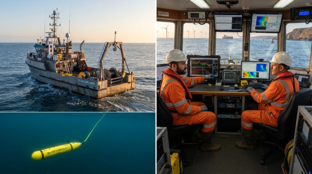
What is a Magnetometer?
A Magnetometer is a survey instrument that measures small changes in the Earth’s magnetic field.
When a large metal object such as a shipwreck, pipeline, anchor, unexploded ordnance (UXO), or steel cable is present below the seabed or underwater, it changes the natural magnetic field around it.
The Magnetometer detects these changes and records them as magnetic anomalies. Surveyors study these anomalies to identify the location of buried metal objects.
Unlike sonar systems, a Magnetometer does not create images of the seabed. Instead, it detects the magnetic effect produced by metal objects.
Why is a Magnetometer Important?
Many underwater metal objects are completely buried beneath sand or mud and cannot be seen with cameras or sonar.
A Magnetometer helps locate these hidden objects before marine construction, dredging, offshore installation, or cable laying begins.
Finding these objects early improves safety, reduces project delays, and helps engineers plan their work more accurately.
How Does a Magnetometer Work?
A Magnetometer is usually towed behind a survey vessel inside a waterproof towfish.
As the vessel follows planned survey lines, the Magnetometer continuously measures the Earth’s magnetic field.
When the sensor passes near a ferrous metal object, the magnetic field changes.
The system records these changes together with the vessel’s position, allowing surveyors to identify the exact location of the magnetic target.
The collected data is later processed to create magnetic anomaly maps.
Main Parts of a Magnetometer System
A complete marine Magnetometer survey system usually includes:
- Magnetometer Sensor
- Towfish
- Tow Cable
- GNSS Receiver
- GNSS Antenna
- Data Acquisition Computer
- Geophysical Survey Software
- Winch
- Power Supply
- Survey Vessel
Each part works together to collect accurate magnetic data during the survey.
Where is a Magnetometer Used?
A Magnetometer is commonly used for:
- Marine Geophysical Surveys
- Offshore Oil and Gas Projects
- Pipeline Route Surveys
- Cable Route Surveys
- Shipwreck Detection
- Unexploded Ordnance (UXO) Surveys
- Harbour Development
- Port Expansion
- Dredging Projects
- Archaeological Surveys
- Military Surveys
- Offshore Wind Farm Projects
Advantages of a Magnetometer
A Magnetometer can detect buried metal objects that cannot be seen from the surface. It works in clear or muddy water, covers large survey areas efficiently, improves project safety, and provides accurate information for marine engineering and geophysical investigations.
Magnetometer vs Side Scan Sonar
A Side Scan Sonar creates detailed images of the seabed surface.
A Magnetometer detects buried or submerged metal objects by measuring changes in the Earth’s magnetic field.
In many marine geophysical surveys, both systems are used together because they provide different types of information.
Common Applications
A Magnetometer is widely used for:
- Shipwreck Detection
- Pipeline Detection
- Cable Detection
- UXO Surveys
- Offshore Construction
- Marine Archaeology
- Dredging Support
- Harbour Surveys
- Seabed Clearance
- Environmental Studies
Frequently Asked Questions
Can a Magnetometer detect non-metal objects?
No. A Magnetometer is designed to detect objects that affect the Earth’s magnetic field, such as iron and steel. It cannot detect non-metallic objects like plastic or wood.
Can a Magnetometer detect buried pipelines?
Yes. It is widely used to locate buried steel pipelines, even when they are covered by sediment.
Does a Magnetometer create underwater images?
No. It measures magnetic field changes and records magnetic anomalies. It does not produce visual images like a sonar system.
Can a Magnetometer be used in rivers and lakes?
Yes. It can be used in rivers, lakes, reservoirs, harbours, coastal waters, and offshore environments.
Conclusion
A Magnetometer is one of the most important instruments used in marine geophysical surveys. It helps surveyors locate buried and submerged metal objects by measuring changes in the Earth’s magnetic field. Its ability to detect hidden pipelines, shipwrecks, cables, and other ferrous objects makes it an essential tool for offshore engineering, dredging, marine archaeology, and underwater construction projects.