
Multibeam Echo Sounder (MBES)
High-Resolution Seabed Mapping for Modern Hydrographic Surveys
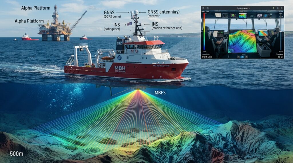
A Multibeam Echo Sounder (MBES) is an advanced hydrographic survey system used to measure water depth and create detailed three-dimensional maps of the seabed. Unlike a Single Beam Echo Sounder, which measures depth at only one point beneath the vessel, MBES transmits hundreds of acoustic beams simultaneously across a wide swath of the seabed.
This technology allows hydrographers to collect large amounts of accurate bathymetric data in less time, making it an essential tool for offshore engineering, port development, dredging, pipeline routing, cable installation, and marine research.
What is a Multibeam Echo Sounder?
A Multibeam Echo Sounder is a sonar system that uses multiple acoustic beams to measure water depth over a wide area beneath a survey vessel. The collected data is processed to create high-resolution bathymetric maps and digital terrain models of the seabed.
MBES provides complete seabed coverage, enabling surveyors to identify underwater features, slopes, wrecks, pipelines, rocks, and other seabed objects with high accuracy.
How Does MBES Work?
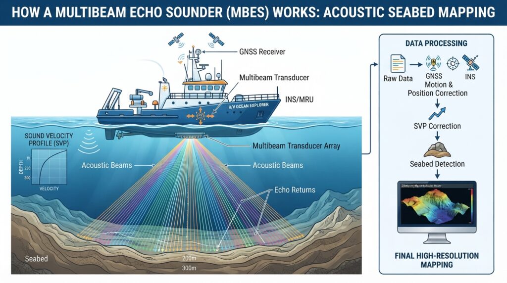
Step 1 – Sound Transmission
The transducer array mounted beneath the survey vessel transmits hundreds of acoustic beams in a fan-shaped pattern.
Step 2 – Sound Reflection
The sound waves travel through the water and reflect from the seabed.
Step 3 – Echo Reception
The returning echoes are received by the transducer array.
Step 4 – Position & Motion Correction
GNSS, INS/MRU, and heading sensors correct the data for vessel position, roll, pitch, heave, and heading.
Step 5 – Sound Velocity Correction
A Sound Velocity Profiler (SVP) provides sound speed measurements to improve depth accuracy.
Step 6 – Data Processing
Specialized hydrographic software processes the collected data to generate accurate bathymetric maps and 3D seabed models.
Main Components
Main Components
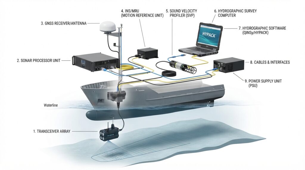
Multibeam Transducer Array
Sonar Processor
GNSS Receiver
INS / Motion Reference Unit (MRU)
Heading Sensor / Gyro Compass
Sound Velocity Profiler (SVP)
Survey Computer
Hydrographic Survey Software
Power Supply
Applications
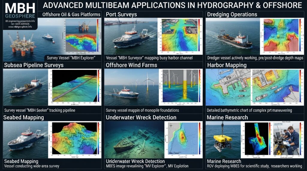
MBES is widely used for:
Hydrographic Surveys
Offshore
Engineering
Port and Harbor Surveys
Dredging Projects
Pipeline Route Surveys
Submarine Cable Route Surveys
Offshore Wind Farm
Surveys
Seabed Mapping
Navigation Channel Surveys
Environmental Monitoring
Marine Research
Wreck Detection
Advantages
Full seabed coverage
High-resolution bathymetric data
Fast data collection
Accurate 3D seabed models
Detects underwater objects
Suitable for shallow and deep water
Reduces survey time
Limitations
Higher equipment cost
Requires experienced operators
Needs accurate calibration
Sensitive to vessel motion
Larger data files require
powerful processing software
Popular MBES Models
NORBIT iWBMS Series
Kongsberg EM2040
Kongsberg EM712
R2Sonic 2024
Teledyne T20-P
CHCNAV HydroBeam Series
Typical Technical Specifications
| Parameter | Typical Value |
|---|---|
| Operating Frequency | 200–700 kHz (Model Dependent) |
| Beam Count | Hundreds of Beams |
| Swath Coverage | Up to 7× Water Depth |
| Depth Range | Shallow to Deep Water |
| Positioning | RTK GNSS |
| Motion Compensation | INS / MRU |
| Output | 3D Bathymetric Model |
Hydrographic Survey Workflow
Survey Planning
Equipment Installation
Patch Test Calibration
GNSS & INS Setup
Sound Velocity Measurement
MBES Data Collection
Quality Control
Data Cleaning
Bathymetric Surface Generation
Final Charts & Reports
Frequently Asked Questions
What is MBES used for?
MBES is used to create detailed 3D maps of the seabed for hydrographic, offshore, dredging, and marine engineering projects.
What is the difference between SBES and MBES?
SBES measures a single depth point directly beneath the vessel, while MBES measures hundreds of depth points across a wide swath, providing complete seabed coverage and detailed 3D mapping.
Can MBES detect underwater objects?
Yes. MBES can identify underwater features such as rocks, wrecks, pipelines, seabed slopes, and other obstructions with high accuracy.
Related Equipment
Survey Vessel
GNSS / RTK Receiver
INS / MRU
Sound Velocity Profiler (SVP)
Tide Gauge
Hydrographic Survey Software