
EchoScope 3D Sonar
Real-Time 3D Underwater Imaging for Hydrographic and Marine Inspection
Introduction
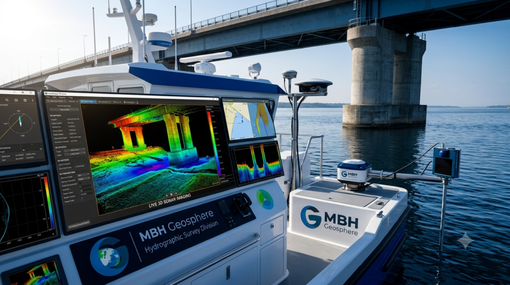
The EchoScope 3D Sonar is an advanced real-time underwater imaging system that provides high-resolution three-dimensional views of underwater environments. Unlike conventional sonar systems that only measure depth or produce two-dimensional images, EchoScope generates live 3D visualizations of underwater structures, objects, and seabed features.
It is widely used for hydrographic surveys, offshore inspections, dredging operations, bridge inspections, port security, underwater construction, and search and recovery missions.
What is EchoScope 3D Sonar?
EchoScope 3D Sonar is a multibeam imaging sonar that captures thousands of acoustic measurements every second to create a real-time 3D image of the underwater environment.
The system enables surveyors and engineers to inspect underwater structures without the need for divers, making operations safer and more efficient.
How Does EchoScope Work?
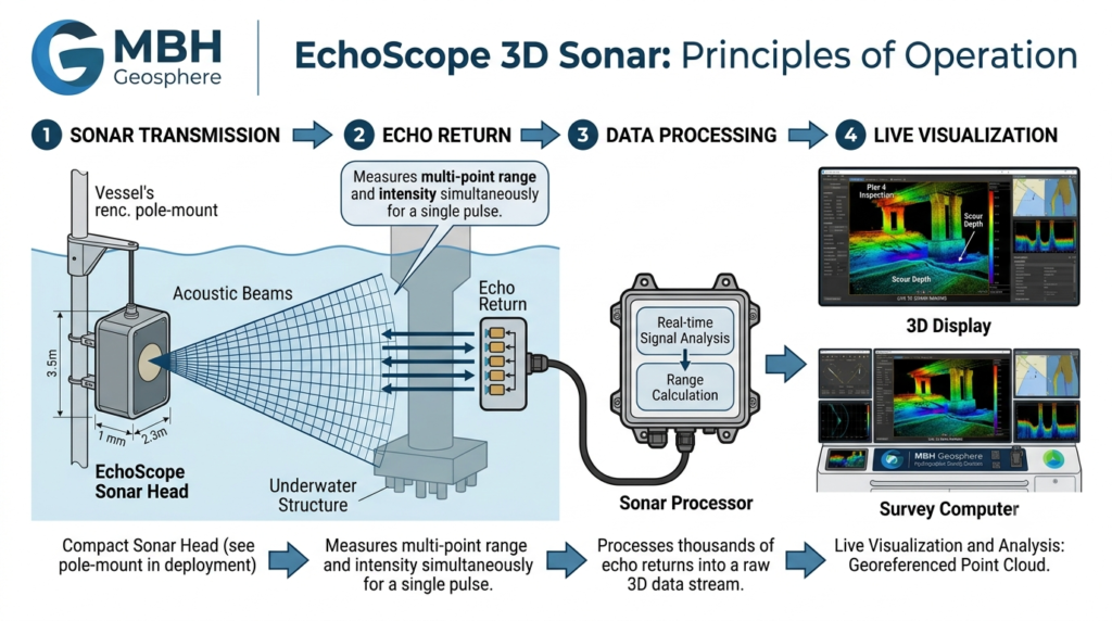
Step 1 – Acoustic Transmission
The sonar transmits multiple acoustic pulses into the water.
Step 2 – Reflection
The sound waves reflect from underwater objects and the seabed.
Step 3 – Echo Reception
The sonar array receives the returning echoes.
Step 4 – 3D Processing
The onboard processor converts the acoustic data into a real-time 3D model.
Step 5 – Live Visualization
The operator views live underwater images on the survey computer.
Step 6 – Recording & Analysis
The collected data is stored for inspection, measurement, and reporting.
Main Components
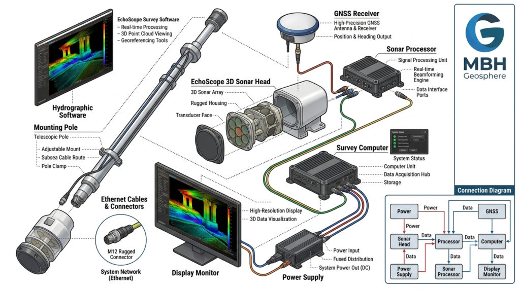
EchoScope 3D Sonar Head
Sonar Processor
GNSS Receiver
Survey Computer
Display Monitor
Power Supply
Ethernet & Data Cables
Mounting Pole or Bracket
Hydrographic Software
Applications
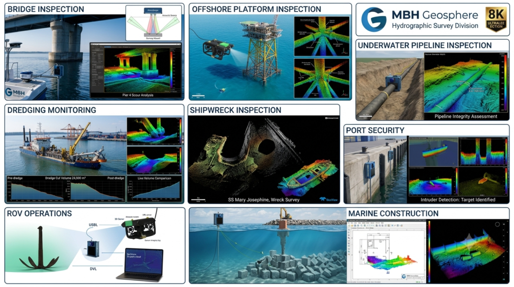
EchoScope 3D Sonar is commonly used for:
Underwater Structure Inspection
Bridge Pier Inspection
Port & Harbor Inspection
Offshore Platform Inspection
Pipeline Inspection
Dredging Monitoring
Wreck Inspection
Search & Recovery Operations
ROV Navigation
Dam Inspection
Marine Construction
Hydrographic Surveys
Advantages
Real-time 3D underwater visualization
High-resolution imaging
No divers required for many inspections
Fast data collection
Operates in low visibility water
Improves inspection safety
Accurate object detection
Easy integration with survey systems
Limitations
Higher system cost
Requires trained operators
Performance depends on water conditions
Large data files require advanced processing
Typical Technical Specifications
| Parameter | Typical Value |
|---|---|
| Technology | 3D Imaging Sonar |
| Imaging | Real-Time 3D |
| Frequency | Model Dependent |
| Range | Up to Several Hundred Meters |
| Output | 3D Point Cloud & Live Imaging |
| Integration | GNSS, ROV, USV, Survey Vessel |
Typical Workflow
EquipmentInstallationSonar CalibrationGNSS IntegrationLive Underwater ImagingData RecordingQuality Check3D Data ProcessingFinal Inspection Report
Frequently Asked Questions
What is EchoScope used for?
EchoScope is used to create real-time 3D images of underwater structures, objects, and seabed features for inspection and survey purposes.
Can EchoScope replace divers?
In many inspection tasks, EchoScope reduces or eliminates the need for divers by providing detailed underwater imaging from the surface.
Can EchoScope be installed on a USV or ROV?
Yes. EchoScope systems can be integrated with survey vessels, USVs, ROVs, and fixed inspection platforms.
Related Equipment
Uncrewed Surface Vessel (USV)
Multibeam Echo Sounder (MBES)
Side Scan Sonar (SSS)
ROV
GNSS Receiver
Hydrographic Survey Software